Kahoot! is a great tool to create fun classes and improve students engagement. Learn how to get started with Kahoot! on your BenQ Interactive Display.
6 Ideas for Fun Geography Class Activities with BenQ Boards
- Teacher Tips 'N Tricks
- Interactive Displays for Education
- 2022-01-19
We all live in a global village and there is no denying this fact. And it’s an internet-powered village. We are all affected by globalization, in one way or another. You can see kids in the US, Asia, and Europe sporting the same clothes, using the same digital devices, and having similar dreams and wishes.
In this globalized, tech-powered and increasingly smaller world, your students will very likely grow up to be members of international teams. If you’ve ever been exposed to an international, multicultural environment, you realize that regardless of these similarities, people still differ in many ways. Each culture and every location is different.
To avoid friction, we need to keep those differences in mind, but first we need to know about them. Starting your students on the path to global awareness and global citizenship can happen in your geography class. We dare say, your role as a geography teacher may never have been more important than it is now.
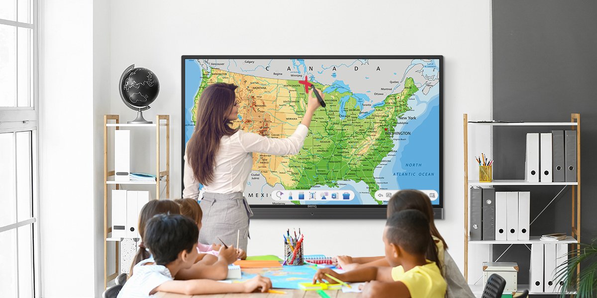
A smart board from BenQ is a great, not-so little (at up to 86") helper to you as a geography teacher. It can help you deliver amazing geography classes that are perfectly suitable for your students’ needs and preferences, and raise true global citizens of the future.
Here are 6 fun, engaging geography class activities examples that your students will love for the BenQ interactive board in your classroom.
6 Fun, Engaging Geography Class Activities Examples for BenQ Interactive Displays
It’s All About the Map!
The undefeated pound-for-pound geography teaching MVP is definitely the trusty old map. The art of cartography came a long way from where it started, but has been stagnant for a while. Until recently.
Nowadays, the amount of data available for free and directly attached to online maps makes it a completely different tool than the one in an atlas you may remember from your own schooldays. It’s used differently as well, but also presents a ton of opportunities that weren’t available previously. Large paper maps on the wall may just be a thing of the past, too.
Google makes an array of map tools available for free for you to use in your classroom. Zoomable, interactive, and containing more data than simple geographic locations, these are an amazing tool for teaching geography.
Depending on your needs, you may choose to use either Google Maps or Google Earth. To use these tools, simply go to the Firefox browser on your BenQ interactive board, type the web address of either tool, press enter, and see the site come up on the large display.
With easy navigation and quick zoom, these tools present opportunities for a more in-depth analysis of the map. You can zoom in an out with same gestures as you would use on your smartphone, or by clicking the “+” and “-“ icons. Pan the map around by sliding your finger across the board as if you were pushing a globe to turn it to the desired location.
With Google Street View, you can show your students not only the relative locations of places you want to present, but also real life images from those locations that can be navigated as if you were taking a walk around what the place you’re showing. For instance, here is a link to Google map showing locations of the World Wonders.
National Geographic also has made available a very useful tool for you to teach various aspects of geographical knowledge. Their "MapMaker" allows you to create custom maps that you can use to show various data, e.g. ethnicities, locations of volcanos all around the world, world wonders, total production of sugar cane by country, each nation’s most popular dish, and many others interesting factoids. These can then be shared with your students and other teachers. There is also a whole library of ready-made custom maps that others have created. Take a look!
By enabling the floating tool from EZWrite, you can easily annotate on the map you are showing. Use the tool to highlight certain areas, show how isometric lines work by drawing along them, draw a route when teaching navigation on a map, or make notes and comments.
To enable a floating tool, simply press two fingers on the board for a couple seconds, pick up your BenQ pen, and start drawing. Your students will love it!
To save your progress and share it, you can screenshot the map, import it to EZWrite, then make your notes and share with your students as an image or PDF.
Schematics Enhanced
EZWrite, the whiteboarding software from BenQ we’ve mentioned, presents you with a plethora of tools for teaching.
Say you are demonstrating how to read isometric lines. You can upload an image of an isometric map to EZWrite, and have your students come up to the board, pick up a BenQ pen, and draw along a line with the altitude you tell them to highlight.
You may also show how tectonic plates affect each other. Upload an image you find on the internet to EZWrite, and draw arrows to show how the forces of nature are shaping the surface of the planet.
Teaching how meanders are made? You don’t even need to upload an image. Simply draw the initial shape of the river in blue, and then by changing colors and shades show students how river banks move deeper and further into land over time.
Take a Virtual Tour
The pandemic that started in 2020 is still affecting our ability to travel. And even before, school trips may have been difficult to organize due to money and time concerns. Some of them are simply unrealistic, as how many locations abroad can you go to with your students even in the best of times?
While not the same, virtual tours can help you showcase some of the world’s most attractive locations right on the board.
Once again, Google Maps and Google Earth are useful. In addition, National Geographic shares free thematic tours using Google Earth that will keep your students entertained and showcase more than a simple map. The tours feature videos, stories, photos, and other multimedia that can enrich your instruction quickly, simply, and with no effort, as it’s ready to use!
A Shot at Becoming Travel Consultants
Global awareness and collaboration are two characteristics that may just prove key to career success for your students. The second aspect can be developed through group activities.
Divide your class into small groups, and have them work on putting together a one-week travel plan, e.g. a “Eurotour”, by researching locations they are interested in, finding attractions and highlights, and making a travel brochure on their own devices.
Each group can then easily share their results on the board by wirelessly mirroring their device screen to the BenQ board via InstaShare software. To ensure success with InstaShare wireless mirroring, make sure their devices are connected to the same network as your BenQ display.
This activity will help your students acquire new knowledge about various countries and locations, and practice collaboration as well as digital skills like simple graphic design or PowerPoint presentation creation while preparing the brochure.
Have Some Fun with Trivia or Geography Bee
Checking students’ knowledge doesn’t necessarily have to make your class resent you. You can do it in a fun way.
Many teachers choose to conduct their quizzes or geography bees via Kahoot!, a gamified quiz software and an official BenQ partner. You can download the Kahoot! app to your BenQ board directly from BenQ App Store.
Kahoot! allows you to create your own quizzes to perfectly fit your curriculum. You can upload images to help students get the right answer, or simply ask questions like “where is this located?”. Your students join the game with their digital devices by typing in the code that will appear on the screen before you start the game. See our guide to Kahoot! on BenQ interactive displays here.
* On certain devices, BenQ App Store can be found under name "BenQ Suggests"
Learn Directly from the Source by Introducing Pen Pals
You may have heard of an activity called pen pals. It’s where your students regularly communicate via email or physical post with their counterparts in another region or country, possibly students of a partner school you cooperate with.
Students can share their ideas, worldviews, and unique perspectives on modern life with each other, enriching their horizons. In addition, they’ll see a lot of important details and get context that they would never learn from books and the internet.
Organize a regular exchange like one message a week so they can get a more in-depth conversation going. Every month or so, arrange a video conference with the other school to connect your students even better.
To do so, simply run the video conference on your computer, point the camera to your class (perhaps by placing it right underneath or above the BenQ board), cast the computer screen to the board via InstaShare, and voila!
More Than Just Knowledge
The days of memorizing rivers, mountain locations, and capital cities might be over. It is now more important to know how to find information quickly than to be a walking encyclopedia.
By getting your students attuned to how technology is used by adults on a daily basis and become familiar with various tools and systems, you can ensure these future members of the global community enter workplaces not only technologically-skilled, but also globally aware, and therefore more likely on the path to success.
See how else BenQ interactive displays help you grow smart students in smart classrooms.
Teacher Tips 'N Tricks
-
Trends & Knowledge
[Teacher Tips 'N Tricks] Kahoot! on BenQ Boards- Guide to Fun, Engaging Classes
2021.08.16 -
Trends & Knowledge
[Teacher Tips 'N Tricks] 4 Apps You Need to Start Using Now on Your BenQ Board
Here is a list of 4 must-have apps for interactive displays in your classroom that will reshape the way you teach and students learn
2021.09.02 -
Trends & Knowledge
[Teacher Tips 'N Tricks] 5 Websites You Should Be Using Now in Classrooms With BenQ Boards
See 5 examples of websites that can help you teach easier and more efficient and make classes unforgettable, directly from your BenQ Interactive Display
2021.12.03 -
Trends & Knowledge
[Teacher Tips 'N Tricks] How to Prepare Your Students for Collaborative Future in Tech-Rich Classrooms?
Collaboration is a skill your students will need in the future. Now, thanks to BenQ boards, you have a chance to teach your students how to work in a project team!
2021.11.05

